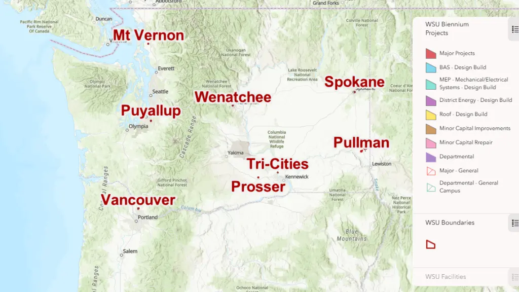
PULLMAN, WA – A new interactive map of capital projects reshaping Washington State University campuses and research sites across the state is now available.
The project was undertaken by the Facility Information Resource Management team within Facilities Services using Geographic Information Systems data. Each project highlighted in the new interactive tool is being undertaken during the current biennium, with projects supported by state, federal, and private funding.
Projects featured on the interactive map are color-coded based on the type of work being undertaken. These range from minor capital repairs to major building projects. Clicking on a highlighted project brings up basic information, including the project manager and a brief description of the ongoing work.
This latest GIS project builds on the university’s existing library of interactive maps, according to Bob Nicols, a manager with Facility Information Resource Management.
We’re excited for the WSU community to use this tool as well as to visit our website and access the other maps we’ve compiled throughout the years.
Bob Nicols, manager
Facility Information Resource Management
Washington State University
“We’re excited for the WSU community to use this tool as well as to visit our website and access the other maps we’ve compiled throughout the years,” Nichols said.
Interactive GIS maps available range from practical tools mapping ADA mobility on the Pullman campus to detailed inventories of different tree species found across the WSU system.
Some of the most significant ongoing WSU capital projects include the new Schweitzer Engineering Hall on the Pullman campus, the $18 million Plant Growth Facility in Wenatchee, and enhancements to the fan experience at Gesa Field.